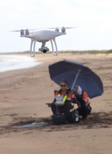
Pendoley Environmental successfully completes first UAV survey
We recently completed our first survey utilising Unmanned Aerial Vehicle (UAV) technology to record aerial imagery of turtle nesting activity along a mainland beach for Chevron Australia. The multi-day survey successfully recorded images at a suitable resolution to detect individual turtle tracks. The data was georeferenced and orthomosaicked for visualisation and analysis by in-house GIS specialists.
To learn more about our UAV capability email Paul Whittock or call us on (08) 9330 6200.
We look forward to hearing from you.